The Basics of Researching New York’s Revolutionary War Land Grants
One of the most interesting, and potentially most frustrating, parts of researching the genealogy of your Revolutionary War ancestors is the concept of “land grants.” Many families have tales about that intrepid veteran striking off into the wilderness and clearing a plot, founding a new village, and becoming one of our revered pioneer settlers. Unfortunately, unless you have a copy of a patent, grant, or deed, verifying this information can be a bit difficult.
This short guide is intended as a starting point for you, to help you understand some of the basic ideas and terminology that you will run across in your research. As always, your own personal family histories may be slightly different — we’ve all come across weird historical circumstances that make little sense to us today — but in general, the process was the same for most soldiers during the Revolutionary War.
Because I live in Central New York and research the CNY Military Tract, the details reflect the process in New York. In addition, the resources I’m using in this article all pertain to one specific military land grant program. Some of the resources can be used for other kinds of research, but you may need to consult additional sources to assist you in those searches.
Background History
On Monday, September 16, 1776, the Continental Congress resolved to raise 88 battalions of soldiers from the individual states. New York was required to raise four, Connecticut eight, Massachusetts Bay fifteen and so forth. Congress authorized a bounty of twenty dollars for privates and non-commissioned officers as well as land grants to officers of amounts reflecting their rank, while NCOs and privates were granted 100 acres. These lands were not already in the possession of Congress — it was expected that they would be paid from lands taken from the British during the war.
These battalions were also known as regiments, so New York was required to raise four regiments of soldiers. All together, a state’s complete collection of regiments was known as its “line,” though the word line used in this way is merely organizational, not in any sense related to military use. You will see on lists of Pensioners, for example, that they served on the “NY Line” or “Conn. Line.” This means that they were Continental Army soldiers from that state, regardless of what regiment or company they served in.
The idea of granting land in exchange for military service was not new with the Continentals; all through the 18th Century, soldiers received land grants (usually of a set amount like 200 acres) for their services in British colonial regiments. Lands granted by military patents during the period 1764–1775 were located mostly in the Champlain Valley north of Albany and the upper Susquehanna Valley bordering Pennsylvania, areas that would have represented the frontier at the time.
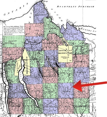
In the mid-1780s, a 4,000 square mile tract was located in the Northwest Territory (beyond the original 13 states) and was set aside for these land warrants. This area came to be known as the U.S. Military District of Ohio. Through the course of the war, New York decided to offer bounty lands of its own, starting with 500 acres for a private or NCO. Later the United States government made an arrangement with the New York State government that any soldier legally relinquishing his claim to the one hundred acres in Ohio should draw a total of six hundred acres in New York, which became the surveyed size of the lots in the Central NY Military Tract. Those who did not relinquish this claim did not receive a deed for 100 acres of the 600-acre lot. Additionally, the owner of each lot was required to 48 shillings for surveyors’ fees within two years or forfeit a corner of 50 acres. The 100-acre lots were known as “State’s 100s” and the smaller lots were known as “Surveyor 50s.” The surveyor’s 50s were always the best corner (NE, NW, SE or SW) of the lot, and when the state auctioned these two kinds of lots in the 1790s, there was a great market in speculations for them (see Scott Anderson for a great discussion of the speculation market).
Previously, as we have seen, Colonial New York soldiers could claim 200 acres of unoccupied land within the old boundaries of the pre-war Province of New York, but this practice was deemed unwieldy, and a plan was devised (about 1784) to divide up the lands anticipated to be acquired from the Six Nations of the Iroquois (today more accurately known as the Haudenosaunee). These negotiations took longer than expected, so New York tried to open lands north of Albany in what became known as the “Old Military Tract” and comprised of lands in Essex, Clinton, and Franklin counties. However, these lands proved, at least to land speculators in New York City, to be far less desirable than those of Central New York and so none were actually granted.
Sidebar: How Townships Worked in New York
Because each “Township” was composed of 100 lots in the area of 600 acres each (roughly six miles square), when political/municipal divisions were being created in the late 1790s and early 1800s, the Townships were broken into smaller entities like towns, villages, and eventually, cities. In New York, township is not a municipal entity, and neither is a hamlet. When you are researching, please keep this in mind, and realize that the hamlet of “Sweet’s Corners” is probably not a place that you can visit for records.
Drawing Lots, or Balloting
The “balloting” process was doubly random, with 600-acre lots numbered from 1–100 in the twenty-five original townships paired with soldier names. The results of this process were published in 1825 based on the original book recording the 1790 drawings. When you read that a veteran “drew” a certain lot, this is the process that is being described. Soldiers themselves were not present (though land agents and speculators may have been); The Balloting Book has a section titled “The Book of Delivery of Patents for Lands in the Military Tract,” which lists each soldier and the person who physically picked up the patent for the land. In this case, the patent functioned as a temporary title, and when deeds were recorded, the patent was proof of ownership. Notoriously, soldiers sold and resold several times over, in the 1783–1790 era, their “rights” to the promised lands, and for several decades court cases were fought to establish clear titles to land. One of the areas of my own research focuses on the soldiers who personally took delivery of their patents, a bit more than 150 of the 2800 or so lots. To find an ancestor who actually settled his own lot is a rare treasure.
I Want to Find Some History, Where Do I Start?
Step One: Your ancestor served in the Revolutionary War, and you want to know if he received any land for his service. If you’re not sure that he served, you can use search engines to find lists of men who served. New York State has much material available about soldiers who served.
Step Two: Was the service in the Continental Army or in a militia regiment? This is a good place to really dig in and learn about what your relative actually did during the war. Many men served in more than one state and were in militias and the Continental Army. Some enlistments lasted the better part of a decade, so you might find evidence of several types. The Daughters of the American Revolution maintain a free database you can search.
Step Three: Look in The Balloting Book (links below; the index on pages 191–214 is modern and contains very few errors) for your target’s last name. If your ancestor is not in The Balloting Book, he almost definitely did not receive a land grant. The book was published in 1825, and so contains a quite definitive list of patentees. That being said, there are mistakes — General George Clinton, who served as Governor of New York during the war and later spent seven years as Vice President, is inexplicably absent from the Book of Delivery list, and so the other sources in the book must be used to track his grants. Not counting name variations, at least one soldier who settled on his grant, Captain John Shepard, is also absent from the Book of Delivery.
Last summer, I drove by a historical marker for the Revolutionary veteran John Albright and became interested in his story, so I will use him as an example of how to follow these steps. The graphic here is from the Index

showing the pages for Jacob and John Albright. Although these Albrights are unrelated, the Index is a good resource for family names, a way to track those brothers, uncles and cousins. Here, page 36 shows us that John

Albright was a corporal in New York’s Second Regiment, and also cross-references his bounty (600 acres) and location of the patent: Township 19 (Homer), Lot 29 along with the date the lot was drawn — July 8, 1790. Pages 91 and 133 provide essentially the same information, though p. 91 specifies Albright’s company as being the Light Infantry. These seemingly redundant pages help us understand how the book was compiled from different sources (the list on page 91 is part of “Connolly’s Original Return,” an accounting of soldiers and officers by Lt. Michael Connolly filed with New York State on May 5, 1783). Because this is a compilation of separate sources, you may find spelling variations or even outright errors, so it is always good to look at each page.
John Albright’s Story
From several sources, it is known that John Albright (1760–1845) joined the New York 2nd Regiment as a teenager — he actually traded his indenture to a tailor for the tailor’s son’s draft notice. He served as a private at Fort Montgomery, Valley Forge, Fort Stanwix (where he was taken prisoner and later released), on the Sullivan Expedition of 1779, and at Yorktown when General Cornwallis surrendered in 1781. At some time he was promoted to corporal and was eligible for a grant of 100 acres from Congress and 500 acres bounty from New York State.
According to Goodwin’s history of Cortland County, John Albright “accompanied by his wife, on horseback… explored his ‘military’ lot; after determining to occupy it, they returned to Charlestown and remained until the spring of 1797. On the 12th of March, they reached Mr. Benedict’s house in Truxton, where they remained until Mr. Albright could erect a small house on his lot. It was of the most primitive character, being composed of logs covered with bark” (pg 343–4). In your research, you will find the records of first settlements in this time period. If you are looking for deeds, the timeline of county formation is useful to know which records might help. Remember that the earliest records may give “Township” information, but even though many of the names of the Military Townships live on in the names of towns, they are not municipalities and some matching of current and former places may be required.
At the time, New York State law required a separate accounting of the military lands, and for the initial period covering 1799/1800, transactions are in The Balloting Book, the original of which was kept in Onondaga County, and is available in an unindexed image form from FamilySearch [note: most images were photographed well, but some are illegible]. The first 250 or so images of this record are a copy of the printed version of the Balloting Book of 1825. The interesting material starts on image 305, which catalogues “A List of Awards of the late Onondaga Commissioners.” Because of the rampant fraudulent reselling of patents by soldiers, their families, and speculators, there were competing claims to titles which were resolved legally by this Commission. The last 93 or so images show how the issues of ownership were settled, including ownership of the State’s 100s and Surveyor 50s. Here is that information for John Albright, Homer Lot 29:
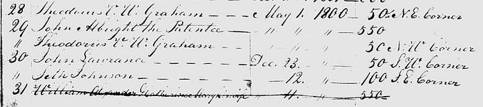
“ Theodorus V.W. Graham “ “ “ 50 NW Corner
From this we can deduce that Albright chose not to pay the 48 shillings, so the Surveyor 50 was sold to Theodorus V.W. Graham, a prominent attorney and land speculator in Albany County.
I have chosen John Albright as my first example because I knew already that he was a soldier to whom the patent for the lot drawn was delivered to in person. The Balloting Book has a list of all the soldiers and to whom the patents were delivered (in a section called “The Book of Delivery.”) Page 150

tells us that John Albright’s patent was delivered to “himself.” The second Albright, Jacob, drew Lot #28 in Solon (the township immediately east of Homer, now a part of Cortland County), and the Delivery List tells us that it was delivered to “John Lawrence,” who took delivery of a total of 39 patents. Mr. Lawrence, like Theodorus V. W. Graham, engaged in land speculation from New York City, hiring local agents to sell subdivided lots.
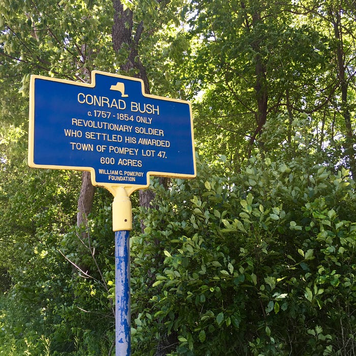
Conrad Bush’s Story
When I began researching soldiers settling on their own patents, I started with a list of about 150 veterans who had their patents delivered personally, which I reasoned would be a good indicator of a veteran’s intention to keep his land. Because Continental soldiers had fought for up to eight years
without pay, and then were forced to wait an additional seven years for land grants, nearly all the people entitled to land had sold their rights — often more than once (leading to a tangle of legal battles in the early 1800s).
From my list of 150, I found about a dozen of these did settle their own land. Researching so many names took some time, and during this time, I encountered several soldiers who were verifiably settlers, but the Balloting Book listed some other person as having taken delivery of the patents. I now have a list of closer to two dozen verified settlers, and on that list is Conrad Bush, matross in the New York Regiment of Artillery.
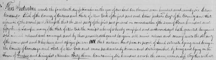
In the Book of Delivery, Bush’s patent is listed as being delivered to “Gen. Clinton for said Bush.” Many of the patents have similar notes of one person picking up the patent for another, but few of these are for the original patentee. Generals George and James Clinton did not engage in land speculation to the degree that other officers did (they even held onto some of their bounty lands until their deaths), so whichever Clinton took delivery of the patent, he must have been merely acting as a proxy for Conrad Bush. Indeed, in the 1790s, Bush may have intended upon not settling on the frontier, because the Onondaga County Property Records record a 1796 deed between Conradt Bush and Elias Jackson, Esq., conveying all of Lot #47 to Jackson. Despite this sale, Conrad Bush did settle on Lot #47 in about 1800,
allegedly after removing the Shattuck family of Joseph and his nine adult sons, who reportedly thought they had legal title (a quick check of Onondaga County grantees shows no deeds recorded for any Shattuck on Pompey Lot #47). At that time, it was determined that Conrad Bush held legal title to the land, so the original sale for £450 had somehow fallen through, perhaps on the terms of payment or a mortgage held by Bush. Though many of the early settlers defaulted on their mortgages, which returned the land to the land speculators, I have only found one other instance of a default returning the bounty land to the original patentee, that of Jacob Hicks who sold his Romulus Lot #10 to a James Haskill, and after a 1791 bankruptcy the lot returned to Hicks. There is even some slight evidence that Hicks went on to settle that lot (Hicks drew/owned lots in Locke and Cincinnatus as well that went to heirs).
According to the pictured historical marker and several other sources, Conrad Bush was the only veteran in the Town of Pompey to have settled his own patent. While this is technically true, Thomas Dixon, who drew Pompey Lot #4, settled his land and is buried in Walnut Grove Cemetery Jamesville, Onondaga County. I believe the claim for Bush’s primacy then hinges on the fact that his land became part of the “Town of Pompey” while Dixon’s land was in a different municipality.
Regardless of whether he was the sole settler who fought in the Revolutionary War, it would be difficult to find a man more vividly articulate about the connection between the men fighting the war and their bounty lands. Joshua V.H. Clark relates the story from Conrad Bush that when New York’s soldiers were discharged from service, some shouted “Who will give a pint of rum for mine? Who will give a blanket for mine?” In the mid-1780s, the land bounties were essentially bits of uncharted wilderness, rife with bears, wolves and panthers, not to mention the surviving Onondaga, Cayuga, and Seneca Nations of the Iroquois. Given that uncertain prospect, soldiers might have been happy to gain any “profit” from this land, but Bush was not one of those. “I held on to mine, and I am well off,” Bush told Clark in 1848, when he was reputed to be 94 years old. In his Last Will & Testament, recorded in the Onondaga County Probate records, Bush writes:
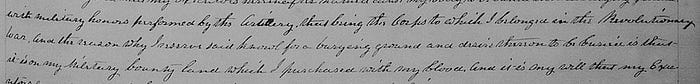
“[T]he reason why I reserve said knoll for a burying ground and desire therein to be buried is that it is on my Military Bounty Land which I purchased with my blood.” To this day, Conrad Bush and some members of his family are buried off Bush Road in Pompey, the site of his original land grant.
The Case of Captain George Fleming
Just outside Auburn, NY, beside the shores of Owasco Lake, one of the eleven Finger Lakes, the Town of Fleming is named for Revolutionary veteran Captain George Fleming. Though I grew up in Cayuga County not too far from Fleming and knew vaguely its being named after a Revolutionary War veteran (a relatively rare occurrence in Central New York), I did not have Captain Fleming on my original list of patentee-settlers. This is because of a the way the lists work in The Balloting Book. Because the kinds of genealogical research we do does not always have easy ways to check accuracy, we often miss some fairly obvious information, so it is good to have groups of people with whom you can share details and double-check research.
In the case of George Fleming, the index has eight entries for “Flemming, George.” But because my research started with the “Book of Delivery,” I would have ignored the notation “Robert Dunlap, by order of Capt. Fleming,” because I initially focused on those soldiers who took delivery of their own patents. Strangely, Fleming is on this list twice, as one of his patents, Town 12, Lot #16 is listed as being delivered to “Aaron Pitny, for Joel Coe, by his order.” But, as I have learned, more settlers had their patents delivered to proxies than took delivery themselves, so that condition alone cannot tell us which soldiers would have settled their own patents. Next, the index lists Flemming on pages 122, 126, and 132 — the pages which list the lots sequentially along with the patentee who drew them. As a captain, Fleming was entitled to 1800 acres total: Page 122 shows George Flemming for Aurelius Lot #95, page 126 has him drawing Scipio Lot #16 (the one delivered to Aaron Pitny), and page 132 has him receiving Locke Lot #6.
The question now is: Did Fleming settle on any of these lots? One of the best sources for information about Revolutionary War veterans, officers especially, is burial records. Doing a search for George Fleming’s burial gives us the information that General George Fleming was buried in the North Street Cemetery in Auburn, NY in 1822. Auburn itself was created from several lots of the Township of Aurelius, so it seems likely that Fleming settled that Lot #95, and further research verifies this. Fleming continued his military service after the Revolutionary War, hence his rank of General. The Town of Fleming, Cayuga County, was created partially from his original Lot #95 in 1823 as a lasting tribute to the man.
Though there are hundreds more interesting stories about the Central New York Military Tract, the several I’ve told here should give you a sense of the kinds of information and resources that are involved with researching land grants in this tract. If you are a beginner, go ahead and dive in and don’t be afraid to ask questions. If you have some genealogical experience under your belt, hopefully this guide helps clarify some of the more confusing aspects of land grants in New York. Good luck!
Some Interesting Facts About the CNY Military Tract:
- New York State reserved the right to any gold or silver found on the lands granted in the Military Tract. From the statute (Balloting Book, p. 13):

- Simeon DeWitt oversaw the surveying operation from Albany, but on the ground the surveying was led by Moses DeWitt, Simeon’s nephew, and Abraham Hardenburgh, who settled near his brother, John, in what would become Auburn, NY. Moses settled on land (Pompey Lot #3)

conveyed to him by another uncle, Gen. James Clinton. He is apparently buried on the lot, but for at least the past century, and probably much longer, the burial has been neglected, and though the Town of Lafayette erected this historical marker in 1776, the small family cemetery has been ignored.
• In addition to the information compiled in 1825’s The Balloting Book, earlier lists of patents and to whom they were delivered were published and circulated in the 1790s to New York county officials, probably in an effort to reel in fraud claims that clogged the courts. No matter what source you use in your research, the goal is to find the pertinent records in the county property rolls, the best verification of what happened.
• The claim that Conrad Bush was the only man to settle his patent in Pompey might not be strictly accurate, but seven of the Townships did have only one veteran settle his patent. At least six Townships had two patentees settle, which means that a dozen of the original 25 Townships had zero patentees settle.
FAQ
Q. My ancestor served in a local militia, and family tradition says that he received a land grant as compensation. How do I find it?
A. From the NY State Archives:
“The state grants were made pursuant to a New York statute of 1790, to individuals holding land bounty rights issued to commissioned officers and private soldiers who served in New York Continental regiments during the Revolutionary War. Militia officers and privates were not eligible for these land grants, unless they served in the Levies, groups of
militiamen drafted into the Continental service.”
— Source: “Land Title Records in the New York State Archives”
New York State Archives Information Leaflet #11
Q. Part of my family is from New England and they moved to the Western Reserve. How do I find out if that was a land grant?
A. In Ohio, the Federal land grants were all within the U. S. Military District. What is now called the “Connecticut Western Reserve” was a part of Northeast Ohio claimed by Connecticut under the terms of their Royal Charter from King Charles II. Beginning in 1796, Connecticut started selling land there. I’ve linked to the official Ohio Lands pdf in the resources, try starting there.
Links:
Ohio Lands. Published & Distributed by the State of Ohio. (free PDF)
All photos and screenshots of public domain material are by the author
This article and material contained within are licensed under
Attribution-NonCommercial-NoDerivatives 4.0 International (CC BY-NC-ND 4.0)
